
Appalachian Mountains vs. Appalachia…what’s the difference?
Everyone has heard of the Appalachian Mountains. And most have heard of the Blue Ridge Mountains. And the Great Smoky Mountains. And the White Mountains. Are they all names for the same place? Or are they all different areas?
And what is Appalachia? Is it all of the mountains? Or does it refer just to the poor hollers of West Virginia?
Are Appalachia and the Appalachian Mountains the same thing?
Yes. And no. And it depends.
It’s confusing. Obviously.
Let’s take a deeper look at what makes up the Appalachian Mountains and Appalachia.
Appalachian Mountains vs. Appalachia
Let’s get this out of the way now…
The terms “Appalachia” and the “Appalachian Mountains” are not interchangeable. The terms can overlap, but they are not synonymous.
The Appalachian Mountain region is a geological and geographic system, with regional and local names, ecosystems, and climate areas.
Appalachia is a cultural, historical, and economic region that encompasses the Appalachian Mountains and some adjacent areas. Appalachian culture also varies from place to place, often changing from one side of a mountain to another.
Appalachian Mountains basics
In a nutshell, the Appalachian Mountains are a long chain of peaks and foothills that run the length of North America. The range consists of a collection of smaller mountains, each with its own local name.
Area:
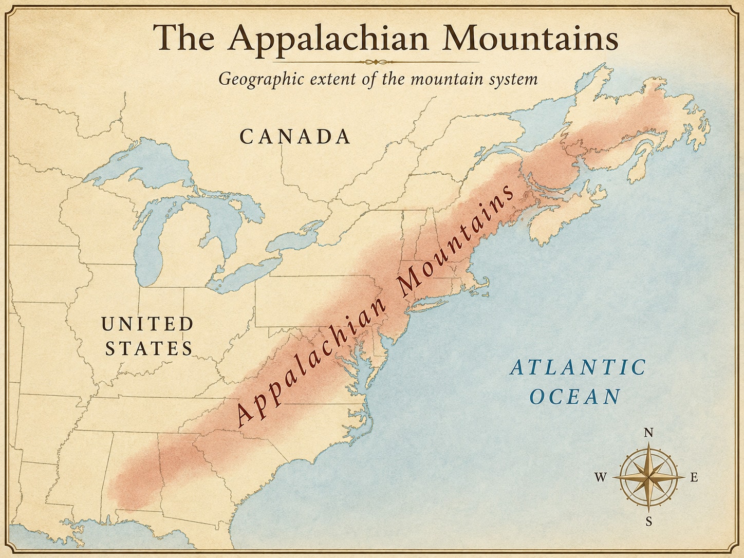
The Appalachian Mountains are huge. Not in height (though some are quite tall), but in area. They extend from northern Alabama to Newfoundland and Labrador in Canada. That’s a distance of 1500 miles (2400km). Add in some of the more remote Canadian segments, and the range extends 2050 miles (3300km). East-to-west, the width ranges from 100 to 300 miles (160 to 480km).
They cover 736,888 square miles (1,908,539 square km).
Altitude:
Colorado is famous for its mile-high mountains. But the Appalachian Mountains are surprisingly tall.
Mount Mitchell in North Carolina is the tallest peak at 6,684 feet (2,037 meters). That makes it the highest point in the U.S. east of the Mississippi River.
Other peaks are just about as tall: Clingmans Dome in Tennessee/North Carolina stands at 6,643 feet (1,924 meters). New Hampshire’s Mount Washington comes in at 6,288 feet (1,917 meters).
Average Elevation:
Most ridges range between 2,000 and 4,000 feet (600 to 1,200 meters) above sea level.
Interesting fact: The total height comparison of the Rockies and the Appalachian Mountains can be a little deceptive. The Rockies are more massive and have a higher total elevation, but they start at a higher foundational plateau. Many Appalachian Mountains have their bases at relatively low elevations, but they rise to heights comparable to some peaks in the Rockies. For example, Mount LeConte in the Great Smoky Mountains rises nearly 5,000 feet from a base of about 1,500 feet. Mount Elbert, the second-tallest mountain in the United States, peaks at an elevation of 14,440 ft (4,400 m) and has a vertical ascent of around 5500 feet.
Population, states, cities and counties
Population: The region is home to 26.6 million residents.
States: According to the Appalachian Regional Commission, the Appalachian Mountains are found in 13 states: Alabama, Georgia, Kentucky, Maryland, Mississippi, New York, North Carolina, Ohio, Pennsylvania, South Carolina, Tennessee, Virginia, and West Virginia.
Counties: It includes 423 counties across those 13 states, including all 55 counties of West Virginia. 119 of these counties are considered high-poverty. This is down from 297 in 1960, showing that the Appalachian region at large has seen considerable economic improvement.
Native American enclaves: There are three federally recognized and five state-recognized Native American tribal communities, found in Appalachian Alabama, Georgia, Mississippi, New York, and North Carolina.
The Appalachian Mountains are a system, not a single ridge
The Appalachian Mountains do not form one continuous row of peaks. They are a collection of ranges, ridges, plateaus, valleys, and highlands extending across much of eastern North America. The easiest way to understand the relationship is to begin with the largest area and work inward.
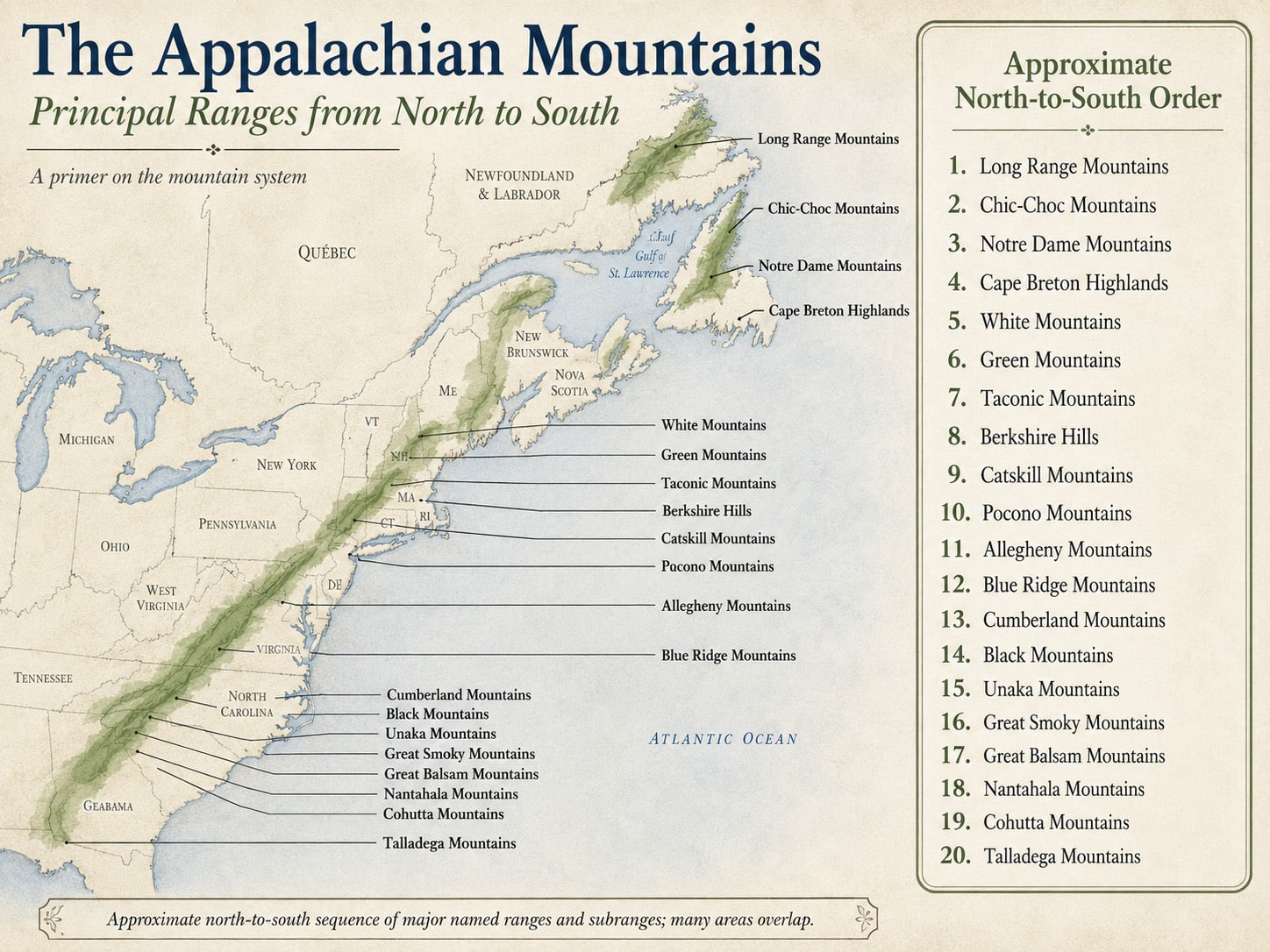
The Appalachian Mountains extend from Newfoundland through eastern Canada, New England, the Mid-Atlantic states, and the South before reaching their southern end in Alabama.
Visitors encounter a long list of regional names along the way. That is one reason a single map rarely answers every question about the Appalachians.
Here are (most of) the component mountain ranges from north to south…
The Appalachian Mountains are not one continuous ridgeline. They are a large mountain system composed of overlapping ranges, highlands, plateaus, and smaller subranges. The divisions below provide a practical north-to-south introduction to some of the principal named mountain regions within that system. The sequence is approximate because several ranges overlap geographically or run alongside one another.
1. Long Range Mountains
The Long Range Mountains extend along the western side of Newfoundland and form the northernmost major mountain section of the Appalachian system. Their landscape bears the strong imprint of glaciation, with high plateaus cut by steep valleys, lakes, and fjord-like waterways. Gros Morne National Park protects some of the best-known Long Range terrain. The exposed rocks there also record several stages in the formation and breakup of ancient continents, making this part of Newfoundland especially important to the study of Appalachian geology.
2. Chic-Choc Mountains
The Chic-Choc Mountains rise across the interior of Quebec's Gaspé Peninsula near the Gulf of St. Lawrence. They form a subrange of the larger Notre Dame Mountains and contain some of the highest terrain in southern Quebec. Their broad summits, steep slopes, and long winters give the Chic-Chocs an appearance quite different from many Appalachian ranges farther south. Much of the range remains heavily forested, while the highest areas support open alpine and subalpine environments.
3. Notre Dame Mountains
The Notre Dame Mountains form a broad Appalachian belt extending through Quebec toward the Gaspé Peninsula and the U.S.-Canadian border. The Chic-Chocs occupy their northeastern section. Unlike the sharper profiles associated with younger mountain systems, much of the Notre Dame landscape consists of rounded, deeply weathered mountains separated by wooded valleys. The range is part of the Appalachian highlands south of the St. Lawrence River and connects the Canadian Appalachians with the mountain regions of New England.
4. Cape Breton Highlands
The Cape Breton Highlands occupy much of northern Cape Breton Island in Nova Scotia. Geographically separated from the mainland ranges by water, they remain part of the same ancient Appalachian system. The highlands are more accurately described as a mountainous plateau than a conventional linear range. Broad uplands are cut by steep river canyons and valleys, with dramatic slopes descending toward the Atlantic Ocean and Gulf of St. Lawrence. Cape Breton Highlands National Park protects a substantial portion of this landscape.
5. White Mountains
The White Mountains dominate much of northern New Hampshire and extend into western Maine. They contain some of the highest and most rugged terrain in the northern United States, including 6,288-foot Mount Washington. Elevation and severe weather create alpine conditions on several of the highest peaks, where tree line occurs well below the summits. The Presidential Range, Franconia Range, and several smaller mountain groups are contained within the broader White Mountain region.
6. Green Mountains
Running north to south through Vermont, the Green Mountains form one of New England's most recognizable sections of the Appalachians. The range gives Vermont its name, derived from the French verts monts, or "green mountains." Long forested ridges dominate much of the landscape. Mount Mansfield is the state's highest summit. The Green Mountains continue toward Quebec in the north and connect geographically with the Berkshire highlands toward Massachusetts in the south.
7. Taconic Mountains
The Taconic Mountains extend along the eastern edge of New York through portions of Connecticut, Massachusetts, and Vermont. Although close to the Green Mountains and Berkshires, the Taconics have their own geological history and form a relatively narrow mountain belt. Their rocks preserve evidence of the Taconic Orogeny, one of the major mountain-building episodes that helped create the early Appalachians hundreds of millions of years ago. The range remains strongly associated with the western New England landscape.
8. Berkshire Hills
The Berkshires occupy western Massachusetts and extend into northwestern Connecticut. They are often called the Berkshire Hills or Berkshire Mountains, although the region contains several overlapping geological features rather than one simple ridge. Forested uplands and rounded summits define much of the landscape. Mount Greylock, at 3,491 feet, is the highest point in Massachusetts. The Berkshires also form a geographic transition between the Green Mountains to the north and Appalachian highlands farther south and west.
9. Catskill Mountains
The Catskills rise west of the Hudson River in southeastern New York. Despite their mountain appearance and name, they are geologically a deeply eroded section of the Appalachian Plateau rather than a folded mountain range like the nearby Taconics. Streams have cut through layers of sedimentary rock to create steep valleys, cliffs, and isolated-looking summits. That distinction makes the Catskills a useful example of how very different geological processes produced the varied landscapes of the Appalachian Mountains.
10. Pocono Mountains
The Pocono Mountains cover a large portion of northeastern Pennsylvania. Like the Catskills, the Poconos are associated with the Appalachian Plateau and are more accurately understood as an elevated, heavily dissected plateau than as a conventional folded range. Rivers and streams have cut deeply into the uplands, creating waterfalls, gorges, and steep wooded slopes. Along the eastern edge, the Delaware River separates the Pocono Plateau from the ridges of northern New Jersey.
11. Allegheny Mountains
The Allegheny Mountains extend southwest from Pennsylvania through western Maryland, eastern West Virginia, and into Virginia. They occupy the central portion of the Appalachian system and form some of its most rugged terrain. High ridges and deeply cut river valleys have historically made travel across the Alleghenies difficult. In West Virginia, the range reaches its highest elevation at Spruce Knob. The Alleghenies also form part of the broader mountain landscape long associated with timber, coal, and the headwaters of major eastern rivers.
12. Blue Ridge Mountains
The Blue Ridge forms one of the longest and best-known mountain belts in the Appalachians, extending from Pennsylvania southwest through Virginia and the Carolinas into Georgia. The range is composed largely of very old metamorphic and igneous rocks. In Virginia it often forms a relatively narrow ridge, but it broadens considerably in North Carolina. The wider Blue Ridge province includes several major mountain groups, among them the Blacks, Unakas, Great Smokies, and Cohuttas.
13. Cumberland Mountains
The Cumberland Mountains form a long Appalachian belt extending through portions of West Virginia, Virginia, Kentucky, and Tennessee. They lie along the southeastern edge of the broader Appalachian Plateau region. Resistant sandstone has produced long ridges, cliffs, narrow valleys, and numerous natural gaps. Cumberland Gap became the best-known passage through the range because generations of Native Americans, settlers, and travelers used it to cross between the eastern mountains and the interior of Kentucky and Tennessee.
14. Black Mountains
The Black Mountains rise northeast of Asheville in western North Carolina and are part of the Southern Blue Ridge. This compact range contains several of the highest summits in the eastern United States. Mount Mitchell reaches 6,684 feet and is the highest point east of the Mississippi River. The range's elevation supports cooler forests and high-elevation ecosystems more commonly associated with regions much farther north. The Blue Ridge Parkway passes along the southern portion of the Black Mountain area.
15. Unaka Mountains
The Unaka Mountains run along sections of the Tennessee-North Carolina border north of the Great Smoky Mountains. They belong to the Southern Blue Ridge province and include high ridges associated with the Roan Highlands and surrounding mountain country. The name "Unaka" has historically been applied somewhat differently on maps, sometimes encompassing a broader group of ranges along the state line. For a general visitor's primer, it is best understood as one of the major border ranges linking the central and southern sections of the Blue Ridge.
16. Great Smoky Mountains
The Great Smoky Mountains rise along the North Carolina-Tennessee border and form one of the best-known subranges of the Southern Appalachians. They are part of the Blue Ridge physiographic province, although they retain a distinct geographic identity. Great Smoky Mountains National Park protects much of the range. High rainfall and large elevation changes contribute to exceptional biological diversity, while the ridges are known for the blue-gray atmospheric haze that helped give the Smokies their English name.
17. Great Balsam Mountains
The Great Balsam Mountains lie in western North Carolina between the Asheville area and the Great Smokies. They form part of the Southern Blue Ridge and contain numerous summits above 6,000 feet. Cold Mountain, Black Balsam Knob, and the Shining Rock area are among the range's better-known landmarks. The Blue Ridge Parkway crosses the Great Balsams at some of its highest elevations, giving visitors relatively easy access to landscapes that include spruce-fir forests, open balds, and high mountain watersheds.
18. Nantahala Mountains
The Nantahala Mountains occupy the far southwestern corner of North Carolina near the Georgia border. They form part of the broader Southern Blue Ridge and include steep, heavily forested terrain cut by streams flowing toward the Little Tennessee River system. Much of the surrounding mountain country lies within Nantahala National Forest. The name comes from the Cherokee language and is commonly translated as "land of the noonday sun," a reference to the deep Nantahala Gorge, where sunlight reaches the valley floor for only part of the day.
19. Cohutta Mountains
The Cohutta Mountains occupy portions of northern Georgia and extend toward southeastern Tennessee. They are among the southern subranges of the Blue Ridge province. The region remains heavily forested and contains large areas of public land, including the Cohutta Wilderness and Cohutta Wildlife Management Area. Deep valleys and long ridges create some of the more remote mountain terrain in Georgia. The range is especially prominent in Fannin, Murray, and Gilmer counties before the Appalachian highlands begin to change character farther south and west.
20. Talladega Mountains
The Talladega Mountains of eastern Alabama are among the southernmost mountainous sections of the Appalachian system. Their ridges are lower than the high peaks of western North Carolina but remain distinct above the surrounding Alabama landscape. Cheaha Mountain rises to 2,407 feet, making it the highest point in the state. Much of the area lies within Talladega National Forest, where long wooded ridges continue the northeast-to-southwest orientation seen throughout much of the Appalachian chain.
For a broader introduction to the range, see Discover the Appalachian Mountains: America’s Ancient, Mysterious Mountains on Appalachian Experience.
How naming systems work
What’s in a name? It depends on who is applying it and why.
Geologists organize mountain systems according to rock formations, landforms, elevation, and geological history. Cultural historians may divide according to settlement patterns, industries, language, music, and migration. Tourism agencies often use the best-known mountain name near a destination. Government and Non-Governmental Organizations have yet another definition.
Regular ol’ people call places by the names they’ve always been called. Sometimes, no one quite knows why.
Each system serves a different purpose. They may overlap or exclude areas.
A Note on Appalachian Mountain Names
A map of the Appalachians can never be reduced to one completely agreed-upon list of ranges. Large geological provinces contain smaller ranges. Some mountain names overlap, while others describe plateaus, highlands, or traditional geographic regions. Local names add another layer.
The Blue Ridge alone contains numerous named ranges beyond those included here, including the Craggy Mountains, Plott Balsams, Pisgah Mountains, and several smaller groups. The northern and central Appalachians contain similar layers of regional names.
For that reason, this list is a geographic primer rather than an exhaustive inventory. It follows the Appalachian system from Newfoundland to Alabama while identifying the principal mountain names readers are most likely to encounter on maps and in regional descriptions.
Appalachia basics
The official guv’mint definition
“Appalachia” has no single boundary accepted for every purpose.
The Appalachian Regional Commission, commonly called the ARC, is a federal-state partnership agency established by Congress in 1965 under the Appalachian Regional Development Act. It offers a wealth of data on the region. The ARC invests in economic and community development, infrastructure, education, and healthcare across the entire Appalachian region.
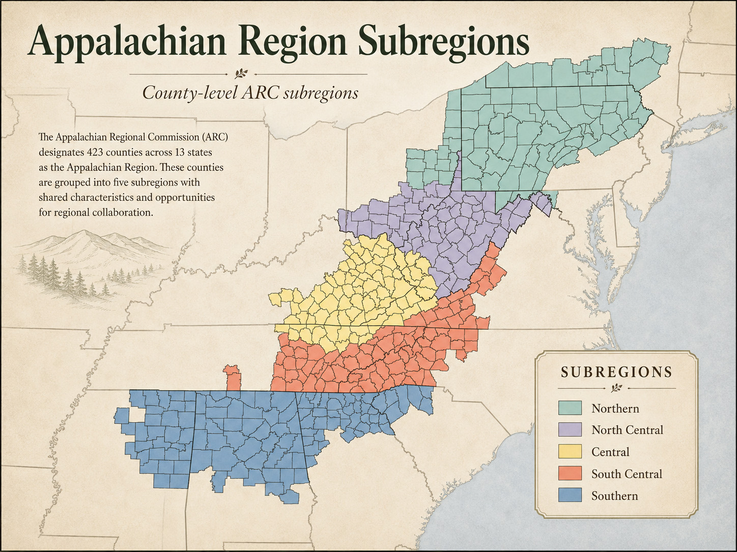
The ARC’s definition of what is Appalachia is the most comprehensive and best-known modern federal definition. According to the ARC, the Appalachian Region contains 423 counties across 13 states and covers approximately 206,000 square miles.
The territory extends from southern New York to northern Mississippi, although the physical mountain chain does not extend that far west. The ARC boundary also includes cities, river valleys, plateaus, farming areas, and communities that are not actually located in mountains.
That boundary was created for economic development and regional planning. It is not a geological map. It’s not a cultural one, though it does outline areas of cultural similarity. But even that is not universal within the entire Appalachian region. Culture in a West Virginia holler is not the same as that found in Gatlinburg, Tennessee, or the Cumberland Valley.
Differences are more pronounced as you go to the extreme ends of the region. Pennsylvania and North Georgia are not easily confused for each other.
Stereotypes do not apply.
Most Appalachian residents do not live in isolated cabins along steep slopes. Or in dirty singlewide trailers in muddly hollers. The countryside is not filled with broke-back barns and old farmhouses with porches packed with hoarded newspapers and old La-Z-Boy recliners. The Appalachian region includes metropolitan areas, college towns, industrial cities, suburbs, and broad agricultural valleys.
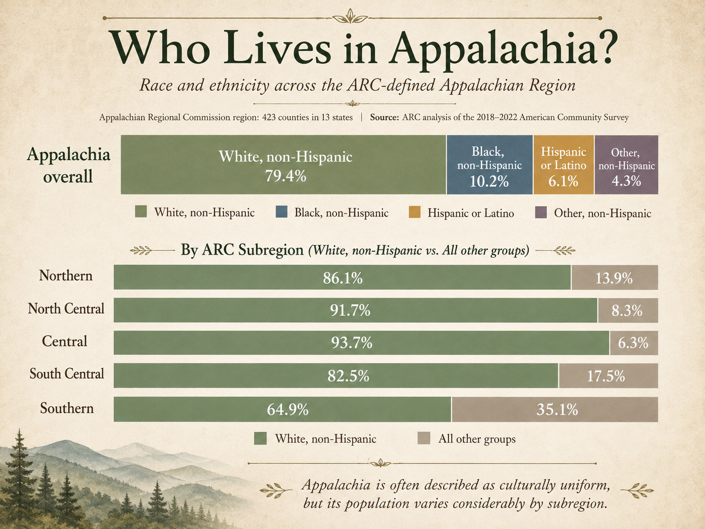
Ethnicity: Both Appalachia and the Appalachian Mountains are diverse, with many ethnicities and several races figuring prominently.
Surprising diversity: Appalachia is often maligned as being mostly white and racist, with few persons of color in the population. Again, it depends on where you are.
According to the U.S. Census Bureau, the United States as a whole is approximately 58% to 61% White (including Hispanic Whites), about 20% Hispanic or Latino, 13% Black or African American, 6% to 7% Asian, and nearly 5% identifying as two or more races.
The non-white populations in the Appalachian subregions are not what most would expect.
- Southern Appalachia is 31% non-white,
- South Central Appalachia is 17.5%,
- Northern Appalachia is 13.9%.
The Central and North Central subregions have non-white populations of 6.3% and 8.3%, respectively. From a historical perspective, this is not surprising. Those mountain areas had few large farms, and so had fewer enslaved people than other Southern locales. For example, fewer than 5% of the population of the area that is now West Virginia were slaves. Similar numbers were found in Eastern Tennessee, North Georgia, and Western North Carolina.
Ethnic origins
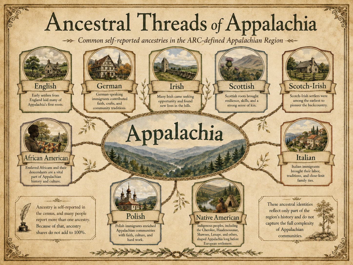
It is a common misconception that most Appalachians are descended from Scots-Irish immigrants. This is certainly true in some areas, but not in others and not across the entire length of Appalachia.
In reality, people of many ethnic groups and countries of origin came to Appalachia. As was common in Northern cities, people with similar origins grouped in broad areas or more concentrated hollers. They lived alongside and then displaced the already established Native American tribal nations, such as the Cherokee, Shawnee, Lenape, and Haudenosaunee (Iroquois), that had lived in the region for centuries.
Economics
The image of a poor, uneducated, inbred redneck living in squalor and playing banjos is alive and well in the public imagination. The image below is a screenshot of a post on X from August 2026. Not only does it play on tired tropes about Appalachia, but it also states as fact statistics that are simply not true.
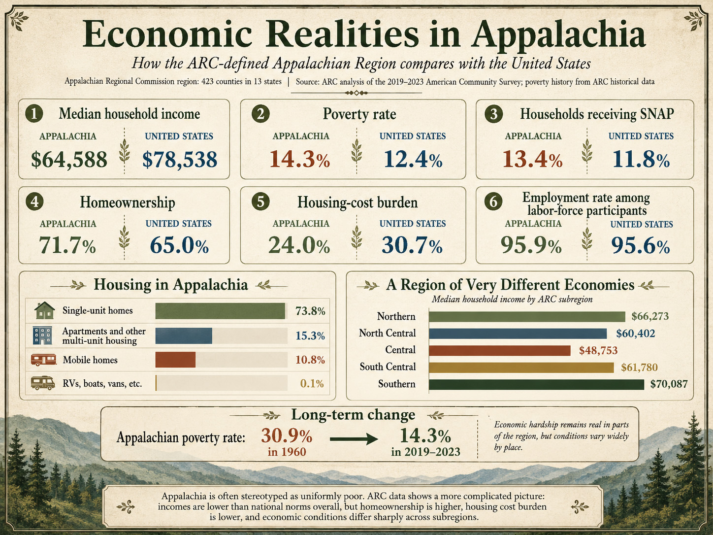
Appalachians earn less income than people in the rest of the United States. This is mitigated by the fact that the cost of living can be much lower. Home prices are considerably less than in other states. Utilities costs are 10-20% lower, as are taxes and government fees.
High-paying jobs are not as common here as in other places. Most jobs are in skilled or unskilled labor, retail, healthcare, education, and tourism. Those wanting high-salary jobs typically have to move away from Appalachia or work remotely in well-paying professions.
The myth of poverty-stricken Appalachia
The concept of poor, uneducated Appalachians is pervasive, but inaccurate. The entire region is not poor. It is also not wealthy.
While the number of high-poverty counties has decreased by almost 60% since 1960, deeply rural counties continue to be economically distressed, with poverty rates still high. In fiscal year 2027, 76 counties are designated as distressed, 85 as at-risk, 240 as transitional, 18 as competitive, and 4 have reached attainment (ranking among the top 10 nationally).
The continuing bias against the culture and place called Appalachia is an echo of the same prejudices and intolerance that drove many of the region’s early settlers to leave the coastal cities for a more secluded, self-governing (or not caring about the government) existence. It is hardly surprising when Appalachians thumb their noses at uninformed and unsympathetic outsiders, especially when those people are using misinformation to make a political point.

The unfair target of political attacks
The image of a poor, uneducated, inbred redneck living in squalor and playing banjos is alive and well in the public imagination. The image at left is a screenshot of a post on the social media platform X from August 2026.
Not only does it play on tired tropes about Appalachia, but it also states as fact statistics that are simply not true. A little over 4 million Appalachians are on WIC (Food Stamps). They make up about 9.5% of all people in the program. From a statistical standpoint, this would make them inappropriate to be the face of such programs.
But Appalachians are an easy target for politically motivated cheap shots. In culture, speech, and way of life, they are different from other Americans.
Cultural Appalachia is harder to pin down
Language, family history, food, music, religion, work, and migration do not stop at county lines. A community outside the ARC boundary may share more culturally with nearby Appalachian counties than with another part of its own state.
The most accurate definition depends on the subject.
While a geological article should follow physical landforms and an economic report should use ARC counties, an article about music, food, or folklore requires a broader cultural definition.
The complexities of Appalachia and the Appalachian Mountains
The answer to the question of "What is Appalachia?" is more complex than first thought. Despite media and political naysayers' characterizations, it is not a hellish area of uneducated, poor Southern white people living in squalid mobile homes. Half of the region is in the North. Nearly 90% of its people are not poor. It has cities and suburbs, art galleries and universities. It has racial and ethnic diversity and cultural history that is alive and still part of everyday life.
Even more diverse are the plants, trees, and wildlife. Sprawling woodlands teeming with deer, bear, and fowl of all kinds are just hours from most of the major cities on the East Coast. Few who live in those urban centers venture into the Appalachian region to experience the nature they hold.
The mountains themselves are old. Older than almost anything on the planet. They have weathered down to the rustic shapes we see today, from Alabama to Canada. They represent millions of years of change, yet remain, in many ways, unchange
Bibliography
Appalachian Regional Commission. About the Appalachian Region
Appalachian Regional Commission. Appalachian Counties Served by ARC
National Park Service. Appalachian National Scenic Trail
National Park Service. Blue Ridge Province
National Park Service. Great Smoky Mountains: Mountains and Elevations
National Park Service. Kuwohi Name Restored to the Highest Peak in the Smokies
National Park Service. Learn About the Blue Ridge Parkway
National Park Service. Mountains of the Blue Ridge Parkway
National Park Service. NPS Geodiversity Atlas: Great Smoky Mountains National Park
Parks Canada. Gros Morne National Park
U.S. Geological Survey. Geology of Great Smoky Mountains National Park
U.S. Geological Survey. Geology of the Southern Appalachian Mountains
U.S. Census Bureau. Quick Facts


0 Comments